Update: We have the latest information on the power outages right here.
Denver, it's extremely blustery out there.
Let's take a look at what happened and why it happened, with a special blend of science and social media.
How intense is it?
Russell Danielson, a meteorologist with the National Weather Service (NWS), has said we've seen gusts in Denver today as high as 70 mph. Their National Wind Technology Center by Highway 93 west of Broomfield has measured an 83-mph gust.
For some perspective: Danielson says the average wind speed for April last year was just shy of 10 mph.
Why so windy?
"We have a strong low pressure system that came out of Wyoming and is going through northeast Colorado right now," Danielson said. In short: this is a sign of cooler weather coming in — and fast — tomorrow. These gales are associated with the drastic temperature change from a rather lovely night yesterday to tonight, throughout which Denver will cool down to about 30 degrees.
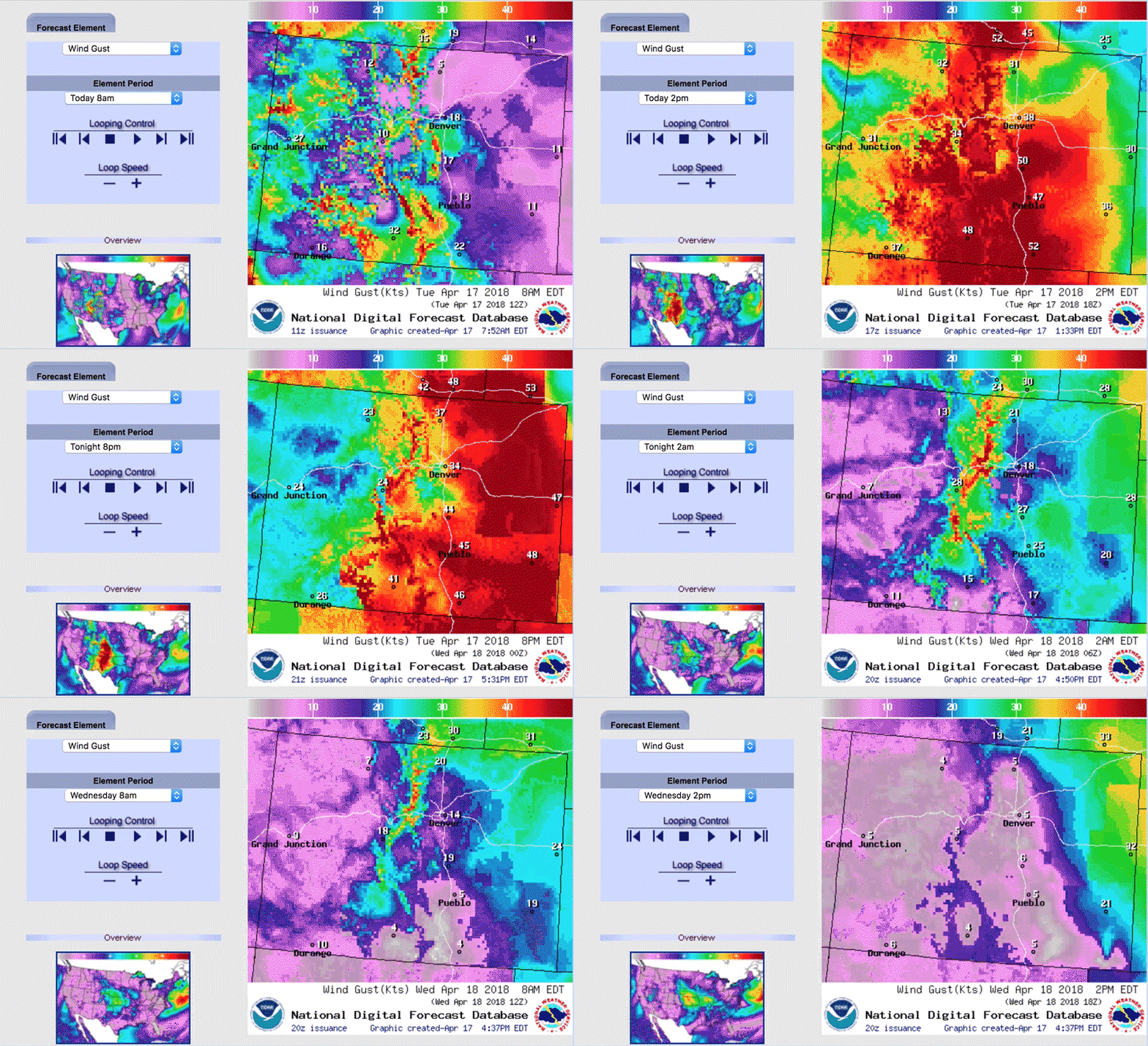
The National Weather Service's gust forecast shows an intense pocket of wind blowing across Denver. It should weaken over the plains tonight around 9 p.m.
Be careful out there.
Social media has been flooded with eyewitness accounts of all sorts of wind-related damage.
A hunk of roof material near the Denver Center for the Performing Arts downtown (here's a closer look at the aftermath) blew off a building and onto a truck.
Here's flying construction material near 13th Avenue and Speer Boulevard:
And a fallen light pole downtown on Curtis Street.
It was even reported by our own Allan Tellis that the wind knocked down a toddler in Five Points.
John Leavitt, a spokesperson for Denver International Airport, told us that the gales have delayed flights by 30 to 45 minutes and, he said, "It seems to be increasing."
Leavitt said planes can take off in high winds, especially if runways align with gusts' directions like today. But DIA only has two east/west runways, and controllers' efforts to funnel flights onto those two strips is causing backups.
But then the wind has caused another another problem today: visibility is low because there's so much dust in the air. Here's an example from Noah Skinner, who reported his plane was in a holding pattern above the airport as he tweeted from midair:
This is also true for cars traversing Peña Boulevard.
Danielson said gusts kicked up a huge dust storm from Great Sand Dunes National Park that reached into Kansas. He also said today's conditions have stoked wildfires.
The AP reports that five new wildfires have sprung up, two homes in Castle Rock were destroyed in fires, and there were evacuations in Pueblo and El Paso.
Power outages are being reported all over the region as well. At 4:45, Xcel Energy's outage map pegged around 450 outage orders affecting more than 47,000 customers. Spokesman Mark Stutz said that while this is a "very unusual windstorm," it's not out of the ordinary for a massive winter storm to knock out power for 100,000 people.
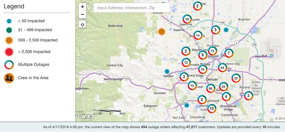
The numbers from Xcel's map, Stutz said, are a good snapshot for now, but he thinks there could be a larger tally once the storm is over and the utility has been able to evaluate all damages.
See anything crazy out there? Send your wind stories to [email protected]!


